
Indie game storeFree gamesFun gamesHorror games
Game developmentAssetsComics
SalesBundles
Jobs
Tags

Outpost 5

A free to download rules light sci-fi rpg · By Nameless Designer

Sector Map "Add Terrain" procedure

A topic by skeolan created Apr 03, 2023 Views: 140 Replies: 2
Viewing posts 1 to 3
(2 edits)

Hi again! We're working through the Sector Map creation process and I'm wondering how to interpret the coordinate-pair results in Step 2, "Add Terrain"

Here's an example:

  1. I roll d6 to see how many terrain features the map has -- I rolled 1.
  2. Roll d6 on the Terrain Table to determine terrain type -- I rolled 3, "Forest".
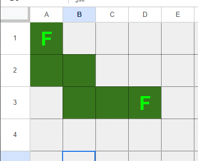
  3. Roll 2d20 for start coordinates [x, y]  -- I rolled 1 and 1, so my forest starts at [1,1] 
  4. Roll 2d20 for end coordinates [x, y] -- I rolled 4 and 3, so my forest ends at [4, 3]

Is this a *rectangle* of forest from [1,1] to [4,3]?


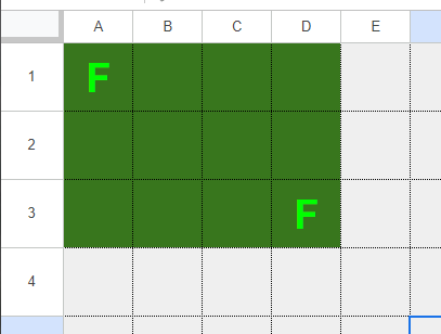
Or a *line* of forest going straight-ish from [1,1] to [4,3]? 


[Images didn't post the first time, edited to re-add them]

Developer

Hey Skeolan, I go with the line approach (but may widen it from 1 square). The purpose of this exercise is to create a few barriers on the map for land based vehicles to navigate around so the line approach works better here. Thanks for the feedback.