
Indie game storeFree gamesFun gamesHorror games
Game developmentAssetsComics
SalesBundles
Jobs
TagsGame Engines

mallatius

10
Posts
1
Topics
1
Following
A member registered Apr 01, 2024

Recent community posts

Some little troubles with JSON file...


Hi Watabou,


Still using the VG with my greatest satisfaction. Congrat !


I am using some JSON exports of VG. I analyze them and create splatmap in UNITY. I am able to create different textures for different features (water, fields, square, ...). I have troubles with the "water" MultiPolygon geometry, in case of tag "island".

Here the PNG :

And a splatmap of the polygons of "water", except the last polygon :

It seems that, contrary to other generations ("pond", "river", ...), in case of "island", the last polygon being equal to "earth", the logic is "earth", minus previous polygons ? Is it correct ?

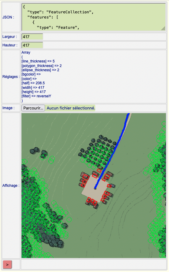
I have an other question. In a generation with tag "estuary", I got that :

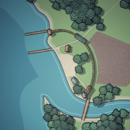
And the splatmap of all polygons of "water" is :

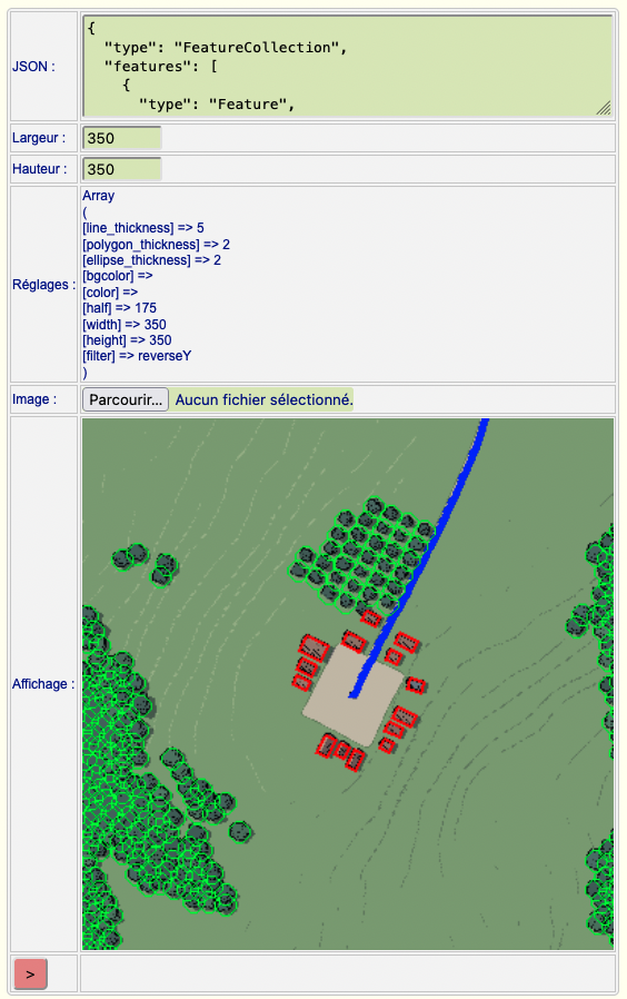
Seems good. But I also draw vertices of each polygon (not obvious to see, but they are the small yellow points). I got "extra" points. Are they still polygons of something ?

Best Regards

Mallatius

Hi,

My goal was to "permanently synchronize" 2D (PNG) and 3D (JSON) for the DM, during his map design. But, I agree with you : I can still use PNG for thumbnail , during map selection, and work only with JSON when DM adds assets.

Thanks for your reply.


To answer your question :

My project is a RPG 3D project, build with Unity. I have a library of 3D buildings, houses, fences, towers, ... I want to use the PNG to present a 2D village or a 2D city to the Dungeon Master. He selects one, and I build a 3D village or city with my Unity assets. And I build that with the JSON file, quite like your City Viewer. And RPG players can play in my 3D village or city after 3D generation.

The first check for me was/is to superpose PNG and JSON, to assure a minimal consistency for the DM. If the DM adds some assets to his village (a tavern, a casern, ...) or remove one, I need superposition between PNG and JSON.

On CG, I have no idea to find the right sizes. VG is square, CG is rectangular.


(1 edit)

Hi,

I have continued on CG and VG tests. I publish my questions here, but it concerns VG, (and CG too), but my tests are currently on VG.

My goal is to add some items on a village map, and to transform the 2D map into a 3D map, like your "City Viewer", but with 3D assets from Unity.

So, I exported PNG and JSON files from one VG seed. And I check the position of roads, buildings, trees. But I have some differences.

I have made "suppositions"/"interpretations" with the JSON file. I know that your JSON file is intended to be used only in CV, but I am interested by it.

So, I write a program which superposes PNG with polygons from JSON. I generated a 500x500 "dead end" village. The JSON gives me a 417x417 "earth" size (-208.6 to +208.6).

When I superpose a 417x417 resized PNG , with JSON, I got that :


(blue=road, red=buildings,green=trees).

After several trials, I got the ideal size, which is 350 (70% of declared size ??) :


I have no idea if I made some geometric errors or miscalulations, or if there is something I forgot to include.

Do you have any idea ?

Mallatius

Hi,

Thanks a lot for your replies. I'll test your suggestions for both CG and VG !

Hi,

I continue to discover and use CG and VG, and I am very happy with them.

I have a couple of questions or suggestions on them :

- in CG : i got sometimes some "triangular" houses. Is it possible to avoid that ? To have houses with at least 4 corners ?


- in CG, you can set the size of City and population with a "size" parameter. In VG, there is not such tag/parameter, it is more with width/height values. Is it possible to have a "size" parameter, and keep width/height for terrain size ? Or is it complicated ?

- Il see in earlier posts, that you thought about making "walls" in VG. I am interested in such feature. Still on you ToDoList ?


Mallatius

Hi,

Thanks for your explanations !

Hi Watabou !

Thanks for your replies.

I am not sure to very well use MCFG URL and its parameters. In my browser, I call https://watabou.itch.io/medieval-fantasy-city-generator, it displays a generated city. If I add "?export=png" or "?export=json", I works, but I get a new city each time.

Same thing if I add "&wall=0" or "wall=1", I got a city with or without walls around the city, but city is regenerated. How can I stay on same city and test some variations by url ?

BTW, is there a list of URL options (wall,castle,...) in MFCG ?

I try the same thing on VG, but except export, which does not have any effect, I am able to get the same village (I suppose as long as I keep the same value in "seed" ?).

But the last point ("error"), I am not able to reproduce it today. My memory was I got a "500 internal error" on MFCG, when adding a "?export=XXX".

(All my tests have been done with Chrome, and most of the time confirm with Firefox).

(1 edit)

Hi,

Fantastic job. Plural : Jobs. I love MFCG, but also the other generators.

I am creating a scenario generator for GameMasters, and I am looking for mapping tools to include in the GM scenarios.

I think that my questions have already been asked, ... but :

- i am interested by getting the 2D map of cities, or caves, or ... but mainly, I am looking for JSON exports, to recreate a 3D view, with my 3D objects (houses, castles, ...). Is it possible to get JSON files on other generators than MFCG ?

- i am interested to "inject" parameters to generators, for instance, houses density, or numbers, or forest density, ... ?

Thanks in advance for your replies.

I say it again : very very great jobs.

PS : I add a third question : I thought I can re-use the URL generated, and change some parameters (walls=0/1, ...), and add export=svg ou export=json to the URL (keeping the seed value). This did'nt work (Error 500). So, I think I have not very well understood the URL syntax/call ? How is it callable directly ?

Mallatius